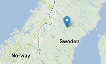


Welcome to Fjällsjö Hiking Eldorado! We hope you will enjoy your stay and enjoy our beautiful nature as much as we do. We have a diverse landscape with lots of water and forests. Walk up the mountains, pass by lakes and along the river in our ancestors footsteps. We believe that we have Sweden´s inlands most beautiful hiking paths, please come and try for yourselves!
With Backe, Jansjö or Silsjönäs as a base point you will have access to sixty kilometers of hiking paths. The advantage to hike here is that it is so easily accessable and perfect for day excursions. Stay in one place and discover new paths every day -there are plenty of paths to explore!
The Fjällsjö region is rich in Culture History and here you can find remains from the Iron- and Bronsage like for example cooking areas, hunting ditches, rock paintings, remains from tarproduction and settlements. It is possible to discover some burnt or cracked stones from old fire places. Keep a lookout for our informative signs along the paths, or join in for a guided tour.
We wish you an enjoyable stay!
Hiking events during 2013
- Guided tours on the paths during the summer
- Bat safari, on the 25th of August
- Hiking day with grilling and guided tour on the 8th of September
- Mushroon ID course in the autumn
Maps of the hiking paths are situated along the paths, in the center of Backe and at Silsjönäs Bygdegård.
You can pick up a printed copy from the Serviceoffice in the center of Backe.
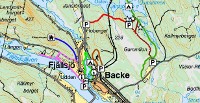
PATHS IN BACKE
Stigen runt Backsjön (3.5km) - The path around the Backe lake
One of the Fjällsjö area most available paths only 100 meter from the center of Backe.
Flottarstigen (2,5km) – The timber logging path
One of the Hiking Eldorado's jewels, an easily accessable path with view over the Fjällsjö river
Kläppstigen (1,5km) – The path to the Kläpp Mountain
Enjoy a wonderful view over Backe and Janjö from the top of the Mountain Kläpp!
Elljusspåret (2,5km) – Lighted path
Lighted excercise trail. See signs from road 346.
Skolskogens trädkojor – The school's tree houses
The so called School forest is situated adjecent to the lighted trail and this is where the school kids have some of their outdoor education.
PATHS IN JANSJÖ
Flobergsstigen (ca 2,7km) – The path of the mountain Floberget
A forest path with contrasts trough a varied landscape of cut and uncut forest.
Källmyrrundan (1km) – The route by the Källmyr bog
A nice route to jogg on in an open landscape & it is also a good short cut to the beautiful green woodland lake called ”Gröna Ögat”/”The Green Eye”.
Djuptjärnsstigen (10,5km) – The path of the Deep Tarn
One of our most beautiful paths where you walk on top of sand banks, passing tens of small lakes, a rock painting of the so called mystical cross (Mystiska korset) and finally you will reach Jansjöbodarna pasture area.
Lidtjärnstigen (1,5km) – The path of the Lidtjärn lake
Good shortcut to the nicest areas of Fjällsjö! Wind shelter with grilling area by the beach of the Lidtjärn lake.
Gammrågan (2km) – The path of the Gammrågan lake
Enjoy the scilence by the banks of the Gammrågan lake and pass historical remains.
Benknäckarn (2,5km) – The bone cracking path
Hilly path for the vigorous!
Ruckastenen (0,3km) – The rocking rock
Follow signs to the ”Ruckastenen” when driving from Backe towards Rossön. Bring wellies!
Landsomberget (0.9km) - The Landsomberget mountain
The ski facility is a nice attraction all year round! Enjoy the view from the top!
PATHS IN SILSJÖNÄS
Bergtuppstigen (3km) – Hike to the mountain called Bergtuppen/”Mountain rooster” and enjoy the view
Brattmyrstigen (8,4km) – See the stone caves, a source of fresh water and an see the historical remains of the tar production.
Gransjöbodstigen (5km) – Visit the cottage Jaktcampen or the wind shelter by Gransjön/”Spruce lake”
Tomfatmyrstigen (1,2km) – Hike over the bog Tomfatmyren/”Empty plate bog”
Ytterbodstigen (13,2) – The hiking eldorado longest path down towards the Vängel area and the river Vängelälven.
Sörånässtigen (2,4km) – Hike to the wind shelter by the bifurcation of the Vägelälven river.
Files:
| Attachment | Size |
|---|---|
| 930.24 KB |